
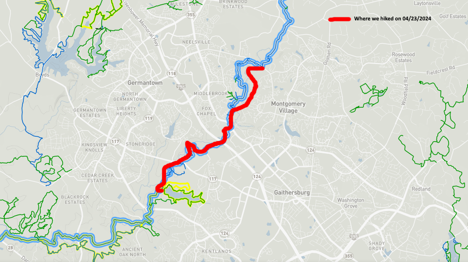
This roughly 7.2 mile day hike took place on Tuesday, April 23, 2024. Participants were Chris Isham, Tim Schmitt, Charlie Johnson, Ron Calabrese and Mike Calabrese. Please note that the mile posts pictured are are the distances from the southern terminus of this trail near the Potomac River. We only went as far as the southern terminus of the Great Seneca Trail within Seneca Creek State Park, MD, which would be between Mileposts 13.5 and 12.5.
WARNING: When starting to hike this section of the SCGT, after crossing Watkins Mill RD going southbound, DO NOT walk straight into the woods. Instead, turn right, cross the bridge over Seneca Creek on the sidewalk, then turn left onto the Seneca Creek Greenway Trail. You must hike this section of trail between Watkins Mill RD and MD355 Frederick RD on the west side of Seneca Creek.
We started this hike around 9:30 AM and immediately made the mistake of walking straight into the woods. There was a trail there. But there were no blue blazes. I knew that something was wrong. But we kept walking on the east side of the creek. The trail would get fainter and fainter. Eventually, we would be bushwhacking. After a mile or so in we had to make a decision. Do we go back to the beginning and start over on the west side of the creek? Do we keep going and cross over at MD355? Do we ford the creek?
We discussed our options over the next mile or so. At one point, we decided that when the trail on the opposite side of the creek came closest to the creek, we would attempt to ford the creek to get back onto the trail. At around the 2 mile mark Charlie decided to cross the creek. He took off his shoes and socks and was successful. The rest of us walked a few hundred feet further. When we got to a large trubutary called Cabin Branch coming in from the east we had no choice. We had to ford the creek as well.
Everyone else took off their socks and shoes to ford the creek except me. Fellow hiker Mike Kilby once told me that he always carried two black plastic trash bags in his pack. If he had to cross a swollen creek, he would wrap the trash bags around his boots and legs and would stay dry as he crossed the creek. I had two black plastic trash bags with me. So I crossed the creek with them around my boots and legs. My feet stayed dry.
When we all got to the other side of the creek we walked up the hill and got on the official Seneca Creek Greenway Trail and proceeded southward. When we got to MD355 we had to yell for Charlie. We found him eventually but again had an issue of where the trail went next.
WARNING: If you hike the Seneca Creek Greenway between MD355 Frederick RD and MD117 Clopper RD you must hike this section of the trail on the east side of Seneca Creek.
Again, we had issues here. There were blue blazes going under the MD355 Frederick RD bridge as well as blue blazes going over this bridge. What do we do now? We walked across the bridge and down to the next intersection, which was called Game Preserve RD. We would be walking parallel to this RD for the next mile or so. But we couldn’t find the trail. So we walked back to the bridge and saw a faint trail going down to the east side of Seneca Creek. We then found blazes and a mile post. We were back in business.
After .8 miles we came to the I270 overpass. Again we saw blue blazes going two different directions. We guessed that the blazes to the left were correct. They were. We went under the I270 overpass, then took a short break.
For the next 1 mile we would veer away from Seneca Creek and walk parallel to a train track. A very long train came through while we were hiking this stretch. We crossed under the train tressle through the B&O Waring Viaduct. It was a neat looking series of arches.
At around the 6 mile mark we walked under the Clopper RD overpass and were now within Seneca Creek State Park. In .7 miles we would be on the Great Seneca Trail and the Seneca Creek Greenway. We would veer away from Seneca Creek, pass under a power line right of way, have about a half mile more of trail, reach a three way intersection with the park RD, travel a short unmarked trail up a small hill to the Kingfisher RD cul-de-sac and Ron’s vehicle. And the hike was then over around 2:00 PM.
Since I was hike leader I take responsibility for the shortcomings on this hike. The documentation for this trail was sparse and the trail distances were conflicting from various sources. Tim and Ron’s trail recording apps had us doing over 7 miles. We probably would have come in under 7 miles if we had not taken two wrong turns. But we survived, I got the entire 30 miles of this trail done after this stretch. And, hopefully, the reader will learn from our mistakes when he or she hikes this challenging but very nice trail.
Mike C
Seneca Creek Greenway Trail Distance Calculator


< Previous Trip Log | << Outdoors | Next Trip Log >