
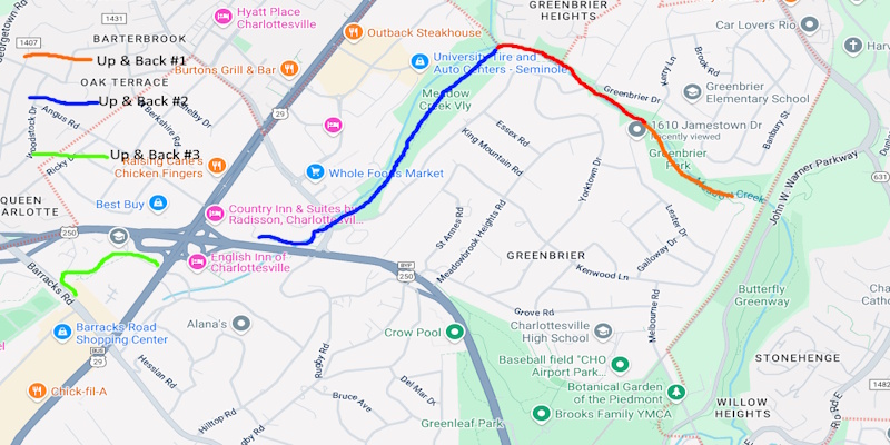
This roughly 3.5 mile (though with up & backs it was really about 7 miles) hike took place on Tuesday, June 3, 2025. It was just me on this one.
Well, I did it. It only took me one year and ten months but I finally completed the 21.5 mile Rivanna Loop Trail that goes around Charlottesville, VA. I left Manassas, VA around 7:00 AM. It was 58 degrees. When I arrived at the Jamestown RD cul de sac at 9:30 AM, it was 68 degrees. So I took a selfie and started out. I planned this hike as three different up and backs. I would drive to various points on the trail and finish what was left to hike. That way, if I needed to, I could abort this hike .
Up and Back #1: I was now within Greenbrier Park. I took the side trail from Jamestown RD to the RT. I then turned right at the bridge and kiosk and hiked .1 miles to Kenwood LA and back. I saw the most people of the entire hike along this stretch: 4 or 5 people, 3 or 4 dogs and 3 or 4 kids. When I got back to the bridge and kiosk I crossed the bridge and continued west for about .6 miles. The trail was level for all of this hike. The only tough part was that I had a stream crossing on Meadow Creek over rocks. It was tough. Someone had strung a heavy duty clothes line across the creek. That helped and probably kept me from falling in. I hiked until the trail started to turn south. I saw an orange streamer tied to a tree. I turned around at this point. I would hike back to this streamer on the next up & back. I got done around 10:30 AM. I saw only one person on this stretch. It was now 81 degrees. So I drove over to the end of Holiday DR off of US29 and started up and back 2.
Up and Back #2: I parked my vehicle at the very end of Holiday DR in front of a vacant building. I then walked a long side walk that went past the RT turnoff to go under US250 via a culvert. I then went over Meadow Creek and turned left on the RT. I went down a short hill and went through a culvert under Hydraulic RD. It was dry except for a puddle at the west end. I was now hiking through Meadow Creek Valley. The trail was very level. A portion of this section looked like it was an old road. I made very good time on this stretch. I hiked for about .5 miles until I came to that orange streamer that I turned around at on up and back 1. I passed one person on the return trip. I got back to my vehicle at around 12 noon. I had been eating a 7-11 sub all morning so I wasn’t that hungry. So I went to the Cook Out fast food place on Emmit ST and treated myself to a chocolate malt.
Up and Back #3: After drinking half of the milkshake in the restaurant I left with half of the milkshake, walked north on Emmit ST and crossed at the intersection of Emmit and Earhart STS. This was a comercial/industrial area that I roadwalked on. There was an interesting Mexican Food Stand half way up the block on the right. I’ll have to stop there next time that I’m in town. Now it got confusing. The trail turned left just before a cul de sac and went over a bridge that had some soft spots among it’s planks. The creek here was unnamed. There was also a weathered piece of paper in plastic that had become wet and distorted. It said that the trail was closed due a landowner decision and to take Emmit to Barracks, turn right on Barracks and then rejoin the trail. I didn’t want to walk all the way out to Emmit and walk around the block. So I went over the bridge with soft boards and walked up to a fence that had surrounded the former Federal Executive Institute. The king recently closed it down. It was supposed to be sold to the city of Charlottesville but his majesty changed his mind and the fate of this property was now up in the air. There were signs that said to keep out but there was an open gate that had a gravel path along the inside of the fence. I was afraid that if I entered, I would be arrested, deported to a random third world country and would have to pay a tariff to get back in. I’m not kidding. So I walked along the outside of the fence and crossed the unnamed creek. I came out to a parking lot for an apartment development. I was now off the trail but not by much. So I turned left and walked to a point where I rejoined the trail. I then turned left onto Cedars CT, then left onto Barracks RD, crossed Baracks, took an image of the first Rivanna Trail sign that I hiked past on 08/13/2023 and then walked back to my vehicle. I finished my chocolate malt along the way back to Cook Out. I disposed of the cup there and started the drive home. It was now 1:00 PM. I made it home by 3:00 PM.
Well, it’s over. I finally completed section hiking the Rivanna Trail around Charlottesville, VA. My son John Calabrese, who is an ultra marathon runner, did it in 3 or 4 hours. It took me one year and ten months. And since I did all up and backs on this trail with the exception of 3 miles, I really hiked about 37 miles on this trail. And with the exception of one section that I did with a group that was sponsored by the Rivanna Trails Foundation, I did most of this trail solo.
I will come back to Charlottesville one day to hike the Rivanna North Trail and hike the Biscuit Run Trail from Biscuit Run Park to I64. I may even come back to hike the trails around Monticello and the future Three Notched Trail between Charlottesville and Waynesboro. This is a nice area. So I definitely will return
Mike C


< Previous Trip Log | << Outdoors | Next Trip Log >