
This page may contain an affiliate ad banner and/or text link. If one clicks/taps on this link and then makes a purchase, I sometimes receive a small commission. Please patronize our advertisers.
This event occured on Thursday, October 19, 2023. It was just me on this one.
This really was more of a recon versus a day hike. I wanted to find out if I could get into the Fredericksburg Quarry area of hiking trails from the western side of this area. My youngest son Andrew and I hiked in from the eastern side of this area in November, 2020. We verified that one could enter this area from 3 different places in Sunrise Park just east of I95 in Fredericksburg.
They were an access road, which was posted no trespassing at the time due to the construction of two new bridges over the Rappahannock River (We walked this one anyway because it was a Saturday and they weren’t working.) The others were the green Naysayer Trail and the red Monolith Trail.
So the goal today was to find how to get into this area from the middle of it west of Gordon W. Shelton BLVD and the west side on River RD. I left Manassas, VA at 10:00 AM and made it to Fredericksburg by 11:05. I went to River Rock Outfitter where my son John works. It was good to see him. We talked about this and that. I remember him telling me that he ran from Fredericksburg Quarry to Motts Reservoir and back once. So I assumed that I could hike from Motts Reservoir into the Quarry area.
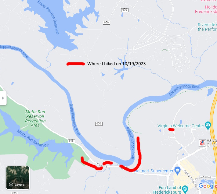
I left John at around 11:30 AM and made it to River RD around 11:45 AM. I originally wanted to hike a loop consisting of the Beach Trail, a connector road going to Gordon W. Shelton BLVD, then Carl D. Silver PKWY, then River RD back to my vehicle. However, when driving down River RD there were no shoulders to walk on. So I decided to do an up and back instead.
There is shoulder parking for two vehicles on River RD just before the boat launch. I wanted to park at the boat launch but it was gated. However, the entrance to the Motts Reservoir dam was open so I parked just inside of it. There was a trail just inside the gate that paralleled the road. I remember a trail coming in to the Reservoir Trail just after crossing over the Motts Reservoir dam.
Taking a chance, I took this trail away from the dam not knowing where it would take me. It paralleled River RD for about a quarter mile, then came out to River RD. Now, there is an old road that is right across the street from this trail intersection. Do not take it as it ends at the Golin Run tributary. Instead, turn right on River RD as there is a bridge with a wide shoulder that crosses this stream.
Then, as soon as you cross this bridge, turn left onto a trail that has a sign saying that it is Prettyman’s Camp Trail. That is the trail that parallels the Rapahannock River into the Quarry area and, at one point, becomes part of the Owl Loop and then the Beach Trail.
Time was of the essense here as I wanted to get back home by 4:00 PM and beat the rush hour. So I decided to walk along the river until I saw the blue dot of myself on the Avenza Maps georeferenced map that I had on their app. So I ended up hiking in about 1.5 miles in, then 1 mile back. I got done around 1:00 PM.
Next I wanted to drive over to Gordon W. Shelton BLVD and see if I could hike into the quarry area from there. There were two places were one should have been able to hike into this area from Gordon W. Shelton BLVD. The first was half way down this road on the left. I verified that the gravel road beside a development was the correct one that went into the quarry area. However, there were posted signs in the parking lot and the beginning of this road. There were also wireless cameras set up in the parking lot at the start of this this gravel road. I felt like if I parked there, that my vehicle would not be there when I returned.
The adjacent apartment complexes were gated so one couldn’t park there. I saw an eighteen wheeler parked across the street from this gravel road. But then again, the road appeared to be posted. There is another gravel road at the end of Gordon W. Shelton BLVD that goes into the quarry area. It is a service road for the huge billboard that one sees going southbound on I95 just south of the Rappahannock River. I don’t recall seing any parking facilities there though.
I intend to contact FredTrails, a bike group in this area and see what their take is on accessing this area. So it looks like the River RD Trail from Motts Reservoir may be the only way into this quarry area from the southwest. I hope that, when Gordon W. Shelton BLVD gets built out, that there will be access to this quarry from it. I didn’t get everything done that I wanted to today. But it was a beautiful day, I had a great hike, I got to see my older son John and I learned something new today. So this adventure was worth it.
Mike C


< Previous Trip Log | << Outdoors | Next Trip Log >