
This page may contain an affiliate ad banner and/or text link. If one clicks/taps on this link and then makes a purchase, I sometimes receive a small commission. Please patronize our advertisers.
This 2 mile up, 2 mile back linear hike took place on Tuesday, March 31, 2026. It was sponsored by the
and was led by Sue Collins.
This is the 150th web page that I have created for this website. I arrived at the northern entrance to Skyline Drive just outside of Front Royal VA at around 9:30 AM. There was some kind of construction work going on right where we were supposed to park. So we parked closer to US340 instead. There were about 30 people on this hike. Sue gave the introduction and we started out at around 10:00 AM. The construction work cleared out as we were starting this hike.
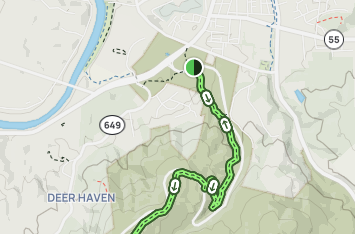
The Dickey Ridge Trail starts at US340 just outside of the Front Royal Town limits and goes parallel to Skyline Drive for 9.1 miles until it reaches the Hickerson Hollow Trail. We would only be hiking to mile 2 and the first Skyline Drive crossing of the Dickey Ridge Trail. The temps were in the low 70’s when we started and would be in the low 80’s when we finished.
I had a number of conversations with various people while hiking this trail. It was all up hill. Gradual at first, but the last mile had some very steep switchbacks. I discovered later that the elevation change on this hike was 445 feet. I had last hiked this section of trail about 25 years ago. I went from the Front Royal Town limits to the Dickey Ridge Visitor Center and back. It was tough then. But it was really tough today. I kept up with the group OK for the first mile. When we got to a concrete marker the trail started to get very steep.
This was supposed to be a wild flower hike. But I think that we missed most of the flowers. We saw some daffodils, skunk cabbage, red bud and some kind of white flowers. But that was about it. I did notice that the leaves on the trees were starting to bloom. That was a sign that spring was truly here.
There were switchbacks the last mile. I was getting very tired. I dropped back and the “sweeps” at the end of the hike waited for me. I think that this blood pressure issue that I am having is taking it’s toll on me. I had to really push myself. When I was almost at the top of the hill and the first Skyline DR crossing, I saw the group walking downhill and towards me. So I got to within 200 feet of the road crossing but never made it.
On the way back down I kept up with the group for about three forths of the way. Towards the end I again got tired and had to take a break. So I took a short break and walked the final 500 feet with a nice lady whose name escapes me. The temps were in the low 80’s when we ended this hike around 12 noon.
This was a tough hike. Sue did a great job leading it. Some in the group went to a restaurant after the hike but I was out of it so I drove home. I had a video chat with my doctor last night. He has changed my blood pressure medicine so we are hoping that my blood pressure gets better. This condition is affecting my hiking ability. I sincerely hope that this gets better. And soon.
Mike C


By Sue Collins


< Previous Trip Log | << Outdoors | Next Trip Log >