
This page may contain an affiliate ad banner and/or text link. If one clicks/taps on this link and then makes a purchase, I sometimes receive a small commission. Please patronize our advertisers.
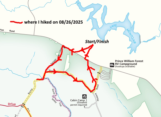
This roughly 2.5 to 3 mile loop day hike took place on Tuesday, August 26, 2026. It was just me on this one.
Back in 2019 a consultant prepared a list of improvements for
in Triangle, VA. That document is
One of the suggestions made in this document was to move all trails fifty feet away from Quantico Creek north and south branches for safety and environmental reasons. Some sections of the South Valley Trail had fallen into Quantico Creek and had to be rerouted. I was a volunteer trail maintainer in this park between 2016 and 2018 and participated in fixing one section of the South Valley trail that had fallen into Quantico Creek South Branch.
Since that time a relocation was done to the Laurel Loop and Birch Bluff Trails as they were precariously close to Quantico Creek North Branch. I’ve hiked this relocation recently and the trail is much improved. You can read my trip log
Here.
So the goal today was to check out the northern terminus of the North Valley Trail and see if it had been relocated and if it had been extended another 3 miles to the Farms to Forest Trail. I arrived at the shopping center at Waterway DR and VA234 at around 8:30 AM, parked my vehicle, crossed VA 234, walked about 150 feet and entered Prince William Forest Park via a fire road called Spriggs LA.
It was in the mid 60’s temperature wise when I started my hike along with low humidity. A beautiful day! I walked mostly downhill for about a half mile, turned right onto Burma RD, Hiked that for another quarter mile and made it to Quantico Creek North Branch. The current northern terminus of the North Valley Trail was here. I then walked across the vehicle bridge over Quantico Creek and looked at the area on both sides of the bridge. No new trail. I was disappointed.
So I turned around around and walked back up Burma RD. Instead of turning left on Spriggs LA, I turned right and continued on Burma RD for about a mile. The fire road was gravelled and went up and down over the rolling hills. I counted three ups and downs.
After about a mile I turned left on Pleasant RD. This road leads to Cabin Camp 1 to the right and VA234 to the left. So I turned left and walked a few hundred feet. I then came across a gas line right of way or ROW. If one turns right on this ROW, it leads to the intersection of VanBuren and Mine RDS. I turned left. Not many people know about this shortcut. It was grassy and had some blowdowns along it. There were pink flags and gas meters along the way to make sure that the gas was flowing. Again, there were ups and downs on this rolling stretch.
Once I reached VA234 I crossed the road and returned to my vehicle within the shopping center. I got a few things at the Food Lion in this shopping center and then went home. This was a good hike. Since I was hiking mostly on gravel fire roads, I had to lift my feet higher and my hips were sore afterwards. But I got some exercise and it was a great day!
Mike C


< Previous Trip Log | << Outdoors | Next Trip Log >