
This page may contain an affiliate ad banner and/or text link. If one clicks/taps on this link and then makes a purchase, I sometimes receive a small commission. Please patronize our advertisers.
This 1.75 mile up, 1.75 mile back or 3.5 mile round trip hike took place on Wednesday, August16, 2023. It was just me on this one.
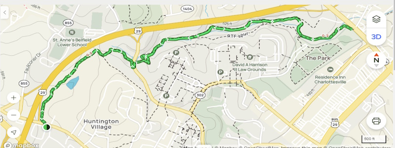
I left Manassas, VA at around 7:00 AM and made it to the shopping center at the intersection of Barracks and Emmit Roads in Charlottesville, VA around 9:00 AM. I parked far out in the parking lot so the authorities would think that I worked there. This parking lot was close to the trailhead and close to the outfitter called Great Outdoor Provision Co. The temperature was around 68 degrees and partly sunny when I started the hike around 9:15 AM.
Initially, I walked up Emmit instead of Barracks. There was a trailhead on Emmit but it would have added another half mile to the hike. So I turned around, walked back to Barracks, turned right, walked half a block and the trailhead was on the left side of the road. The trail itself was all dirt. There were a lot of roots and there were some ups and downs. I used the AllTrails and Google Maps apps to navigate this trail. Verizon cell service was good.
This trail was nestled between the north Campus of the University of Virginia and US250. There were numerous sidetrails to various places on the campus. One thing that was a downer was that you were never more than between 100 and 500 feet away from the noise of the vehicles. You were under tree canopy about 85 percent of the time. The trail was parallel to a small stream whose name I was unable to find. I passed one old, small stone structure. I wasn’t sure if it was an old bridge abutment, an old watering troth or something else..
As far as other hikers/runners/bikers on this trail I was either passed by or I passed by five hikers and one bicyclist. While hiking I thought that the trail was well signed with the RTFsigns and the side trails were well marked. No blowdowns noted. I did think to myself that the trail needs to be weed whacked as the vegitation was growing in on the trail. My wish would come true on my return trip.
The first road that I passed was Leonard Sandridge RD and around mile 1.25. There was a somewhat tough up to get to the road. Once across it I passed by a pond, then went around a horse pasture, then made it then made it to Ivy RD by 10:15 AM. A lot of things around here are named ivy. I believe the reason is that there was an abundence of wild ivy growing along this trail. The UVA Print Center was right across the street from the trailhead. I would think that one could park a vehicle there if one sought permission.
When I reached Ivy RD I turned around, drank an energy drink and started back to my vehicle. I thought that I heard the sound of weed whackers at some point. Then I came across about a half dozen of what appeared to be college students doing trail work along this trail, some side trails and a parallel trail to the main Rivanna Loop Trail. I thanked each one of them for making the trail better. I arrived back at my vehicle at around 11:15 AM.
There were three more things that I wanted to do. First, I walked across the parking lot to the Great Outdoor Provision Co. to check them out. The interior of the store was really neat. Everything was a light colored wood. The floors, the walls, the dressing rooms, everything but the ceiling. And it smelled like a forest! I walked around and noticed that they had some very nice gear. I checked their web site out before this trip. Nice gear but their prices are high. Charlottesville is a lucky town. They have four outfitters: Great Outdoor Provision, L.L. Bean, Orvis and High Tor Gear Exchange.
The next thing that I wanted to do was see if Albemarle County had started building the trails in the new Biscuit Run Park south of Charlottesville. The county website said that it would be off of VA20. I drove I64 to VA 20 south and drove it about five miles to the town of Keene. I saw a number of large forested areas where there could be a park but nothing definitive.
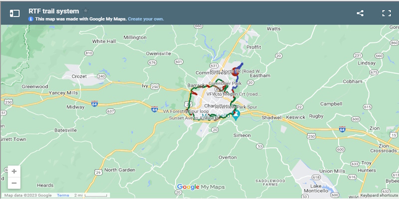
Finally, I started home and stopped at Yoders Country Market near Madison, VA. Initially, I was going to get one of their wonderful sandwiches there. But since I wasn’t super hungry I just bought some caramels, a Mountain Dew and some bananas. I got home around 2:30 PM. There are two trails near Charlottesville named Rivanna. One is the 4.3 mile Rivanna River Trail which is north of Charlottesville, VA. The other is the 20 mile Rivanna Loop Trail around the city of Charlottesville. The latter could be a good Ultra Run for my son John. Just run it five times. I wouldn’t mind hiking another section of this trail someday. If I had a hiking partner with a vehicle, we could stage a vehicle at each end and knock out 3-6 miles at one time. Anyone interested?
Mike C


<< Outdoors | Next Trip Log >