
This page may contain an affiliate ad banner and/or text link. If one clicks/taps on this link and then makes a purchase, I sometimes receive a small commission. Please patronize our advertisers.
This 2.7 moderate loop day hike occured on Tuesday, August 12, 2025. It was just me on this one.
I got to Prince William Forest Park and on the trail at around 7:20 AM. I wanted to get an early start before it got too hot. This is probably the 50th time or more that I have done this loop since I started coming here in the late 1980’s. I’ve hiked it with a lot of different people. And in the 2017-2018 time period, when I was a trail maintainer in this park, I was on a team of four people that redid the trail blazes on about 20 miles of trails including this one.
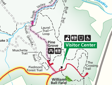
The Laurel Loop Trail started at the end of a former baseball field. It was about a 1 mile down. I did this loop clockwise because the up later on was not as bad as this one would have been. The yellow blazes were for the Laurel Loop Trail. The aqua colored blazes were for the Potomac Heritage National Scenic Trail.
I noticed that someone had added some nice signs to a few of the trails that I passed. They looked similar to signs that I have seen along the Tuscarora Trail in VA, WV and MD. So I am guessing that the Potomac Appalachian Trail Club must have added them. Great addition.
It was in the low 70’s with slight humidity as I was negotating the initial 1 mile down. I thought about this and that and just enjoyed being in the woods. When I got to the bottom of the big down and right before crossing Quantico Creek South Branch, I turned right. I was initially walking close to the creek. But after about .3 miles the trail started slabbing the side of the moutain upward. I was now on a new section of this trail built about three years ago. The purpose of this relocation was to get this trail away from Quantico Creek South Branch as the trail was in danger of falling into it.
After about .5 miles I was at the half way point while ascending a hill and near the intersection with the red blazed Birch Bluff Trail to the left. However, I kept straight on the Laurel Loop Trail and continued a gradual up. I only passed one other hiker on this hike: A lady and her German Shepherd dog (who was not on a leash).
The long up continued until I got to the intersection with The Crossing Trail. It was blazed green. I was around 2.5 miles now. The trail leveled out a bit, went up again and I was at the end of the loop. What is weird is that this trail is not blazed between the Visitors Center and the Playground (which was under construction). It has something to do with park policies forbidding blazing of trails along roads or within picnic areas.
I got done around 8:15 AM. My vehicle was parked about 80 feet from the trail. It was around 78 degrees and more humid. I left and made it home in time to watch Perry Mason at 9:00 AM. I’m trying to work my way back up to doing at least 5 miles a week. I was sweating a lot after this one but felt good. Hopefully, cooler temperatures will be here soon.
Mike C


< Previous Trip Log | << Outdoors | Next Trip Log >