
This page may contain an affiliate ad banner and/or text link. If one clicks/taps on this link and then makes a purchase, I sometimes receive a small commission. Please patronize our advertisers.
This 2.4 mile loop trail hike took place on Tuesday, November 7, 2023. It was just me on this one.
I normally wouldn’t write about this short a distance. But this hike was different than in previous times that I hiked it. Read on and see how.
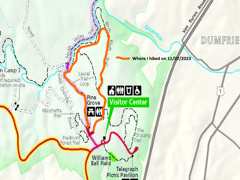
I arrived at PWFP around 9:30 AM. The parking lot was empty. The gameplan was to hike a portion of the yellow blazed Laurel Loop Trail, then the red blazed Birch Bluff Trail, then pick up the Laurel Loop trail again to complete the loop.
The weather was overcast and in the high fifties. Good hiking weather. I started at the Laurel Loop trailhead at the entrance closest to the visitors center. It was a pleasant slighly downhill hike the first quarter mile. The yellow blazes on the trees were the same ones that I painted over six years ago when I was a trail maintainer in this park. I then turned right onto the red blazed Birch Bluff Trail. This trail had an initial short up. Then it was downhill for about a quarter mile.
At one point the trail turned to the left and started going uphill. And the red blazes looked fresh. I had read that they were going to relocate the Birch Bluff Trail away from Quantico Creek South Branch due to erosion. Well, they had done it. The trail was well designed and well blazed. It basically went to the top of the ridge overlooking Quantico Creek South Branch.
After about .3 miles the Birch Bluff Trail intersected the Laurel Loop Trail. I turned right on Laurel Loop and, just before the trail was supposed to turn right and descend the hill to the creek, it kept going on new trail. Again, it was on top of the ridge. The views were not as good as before but the trail was easier to hike.
In about .3 miles I was back on the old Laurel Loop Trail. I continued until the trail turned left, joined the aqua blazed Potomac Heritage Trail and started it’s .2 mile ascent back to the park picnic area. It don’t know if it’s because I lost weight or what but the final ascent was not as difficult as it used to be.
I was on the road by about 10:30 AM and was back home by 11:00 AM. The park service plans to move the North Valley and South Valley trails up to the top of their respective ridges in the future. That will be a nice change as these trails will be much easier to hike. Like today’s was.
Mike C


< Previous Trip Log | << Outdoors | Next Trip Log >