
This page may contain an affiliate ad banner and/or text link. If one clicks/taps on this link and then makes a purchase, I sometimes receive a small commission. Please patronize our advertisers.
This 1.9 mile up, 1.9 mile back or 3.8 mile hike took place on Thursday, April 23, 2026. It was just me on this one.
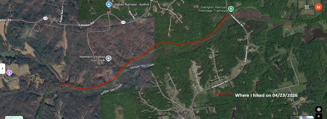
I left Manassas, VA at 8:45 and arrived at the Indiantown RD parking area at 9:50. I made great time and immediately started the hike. Today was the first time that I would be hiking east to west, then west to east. I have to plan hikes along this trail according to how the parking areas are laid out. The temperature was 70 degrees when I started. Excellent weather!
The trail today was similar to the way the trail was the last three outings. It is a former government rail route that is very level, has a few minor curves and stretches for 16.7 miles from Bloomsbury RD to James Madison HWY in King George, VA. Since I’m not up to running it and no one wants to hike it with me using two vehicles, I have to resort to doing short up and backs on this trail.
Today I started at the Indiantown RD parking area at Mile 8.1, then hiked westward 2.1 miles to mile 6.0, took a break, then hiked back to my vehicle. It’s neat hiking all by yourself on a trail. It’s very quiet and peaceful. You hear birds and see butterflies. All is good. Until I reached mile 7.0 and had to walk next to the Northern Virginia Gun Club range for a quarter mile. I know, they have as much right to be there as I have. It’s just that the quiet and peacefullness was shattered for that quarter mile.
Other than the gun noise, nothing unusual happened on this trip. I hiked until mile marker 6, then sat down on the same exposed root that I sat on when I hiked eastbound to this spot earlier this month and took a break. I ate two Jack Links sausage sticks, drank an Ensure and popped an Advil, then started my return trip. My left hip and my feet were a bit sore on the way up. But both felt better on the way back.
My stats were pretty good this time. I made it from Indiantown RD to mile marker 6 in under an hour. I got to mile marker 6 at 10:50 AM. Then, I started back at 11:00 AM and made it back to Indiantown RD before 12 noon. I hiked 2.3 miles an hour. It was around 80 degrees when I got back to my vehicle. I made it home by 1:30 PM and had the rest of the day free to do stuff.
This week I tried to increase my hiking quota from 5 to 7 miles. The reasons are that I want to lose weight to hopefully make my blood pressure stabilize as well as get me in the best shape possible so I can effectively lead a 7.1 mile hike with an 800 foot elevation change over Short Mountain, VA on May 20, 2026.
So now I only have 3 more up & backs to go: Between Indiantown RD and Caledon RD- 2.8 miles (5.6 up & back total); Caledon RD to Owens DR W- 4.0 miles (8 up & back total) via bike; and Owens DR W to US301 James Nadison HWY- 1.8 miles (3.6 up & back total) and I’m done with this one. There is a movement to incorporate this trail into nearby Caledon State Park. Maybe then, they can provide access to this trail from the park via a side trail or a parking lot.
Mike C


< Previous Trip Log | << Outdoors | Next Trip Log >