
This page may contain an affiliate ad banner and/or text link. If one clicks/taps on this link and then makes a purchase, I sometimes receive a small commission. Please patronize our advertisers.
This 1.9 mile easy loop hike took place on Wednesday, December 24, 2025. It was Julie R and I on this one.
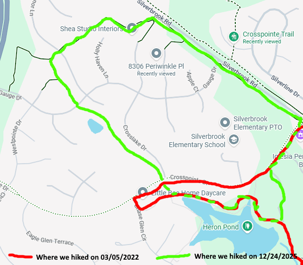
Originally, I led a hike here on 03/05/2022. We had to cut the hike short due to getting lost and my not feeling well. You can view the trip log for that hike
Here.
Then I came back to this area on 03/10/2022, did some up and backs and figured out what we did wrong. But I still hadn’t completed certain parts of this hike that we didn’t do originally. So we did that today. It was a balmy 54 degrees when we started this hike around 11:30 AM on Christmas Eve. We drove from Manassas, VA to Lorton VA and within the Crosspointe development where the trail crossed Gauge DR. I’m going to call this loop the Crosspointe Loop because all of this loop was within the Crosspointe development.
There is room to park three or four cars on Gauge DR where we started. There is additional parking available at Crosspointe Elementary School at around the 5:00 position on this loop when school is not in session. We went north and clockwise. The majority of this loop was in the woods between rows of houses. The development was very nice looking. I’m glad that they let outsiders like myself hike on their trails. We went maybe a quarter mile and came to a “T” intersection. We turned right and walked east about a third of a mile out to Silverbrook RD where we turned right.
Next, we walked south along a paved path parallel to Silverbrook RD for about a half mile. The trail was partially in the woods. The trail was rolling at this point. We then turned right onto Crosspointe DR and were headed in a northwesternly direction. We pased the elementary school, which is an alternative to park at when not in session. After about a quarter mile, we turned left onto a side trail and got to Heron Lake. This is the lake that I could not find the name of on our original trip.
We turned right, walked another quarter mile around the lake and got to a bridge. Right after the bridge the trail forked. Again, I made the same mistake as I did on 03/05/22. We forked left instead of right. As a result, we came out to Chase Glen Circle. There were no signs stating which way to go. So originally, we decided to walk back to Crosspointe RD, then take Crosslake DR. However, right before we got to Crosslake DR, there was the trail. So we took it.
OK, this was the home stretch. The trail was slightly uphill but nothing too difficult. And this loop that we did was asphalt paved all the way around. We went past Giles Pond and, because of the lack of foliage, I could see my Subaru Outback through the trees. So we got done around 12:30 PM and were back home a bit after 1:00 PM. Our original 03/05/2022 hike would have been 5.5 miles if we had done it correctly the first time. I’m very glad that I was able to get this trail hiked correctly this time. Something around 2 miles is nice for a casual afternoon hike.
Merry Christmas & Happy New Year,
Mike C


< Previous Trip Log | << Outdoors | Next Trip Log >