
This approximately 3 mile series of trails occured on Sunday, January 14, 2024, was led by Neil Nelson and was sponsored by:
The Greater Prince William Trails Coalition
This hike was only 3.2 miles from where I lived. I looked it up on Google Maps beforehand so I knew where to go. But I used Waze just in case. Glad I looked up 12775 Classic Springs DR, Nokesville, VA beforehand. The GPS was trying to take me through the area called Independent Hill. I knew that was wrong as I wanted to go to the area called Canova. I found the street and found the trailhead. But the instructions said to go to the above address. It was up the hill from the trailhead. So I waited there. Hike leader Neil Nelson drove by and said that we were meeting at the trailhead. So I drove there. Since this entire area was new, none of it was depicted on Waze.
Like yesterday, a half dozen vehicles piled into the parking lot at around 12:55 PM. It looked like we had about 15-18 people on this trip. The hike started at 1:05 PM. The writeup said that this trail was not open to the public yet. But there were no signs to that affect. The parking lot and the trail were wide open.
Neil told us that the developer brought in a professional trail building company to create this trail. I thought that they did a fantastic job. They used the “Lay of the land” technique of trail building. Instead of going over a mountain, they would go around it and gradually increase the elevation, then gradually decrease it going down over the other side. So it was a pleasant hike. The weather was chilly when we started this hike at 37 degrees. But it felt like it was in the 40’s as the day progressed.
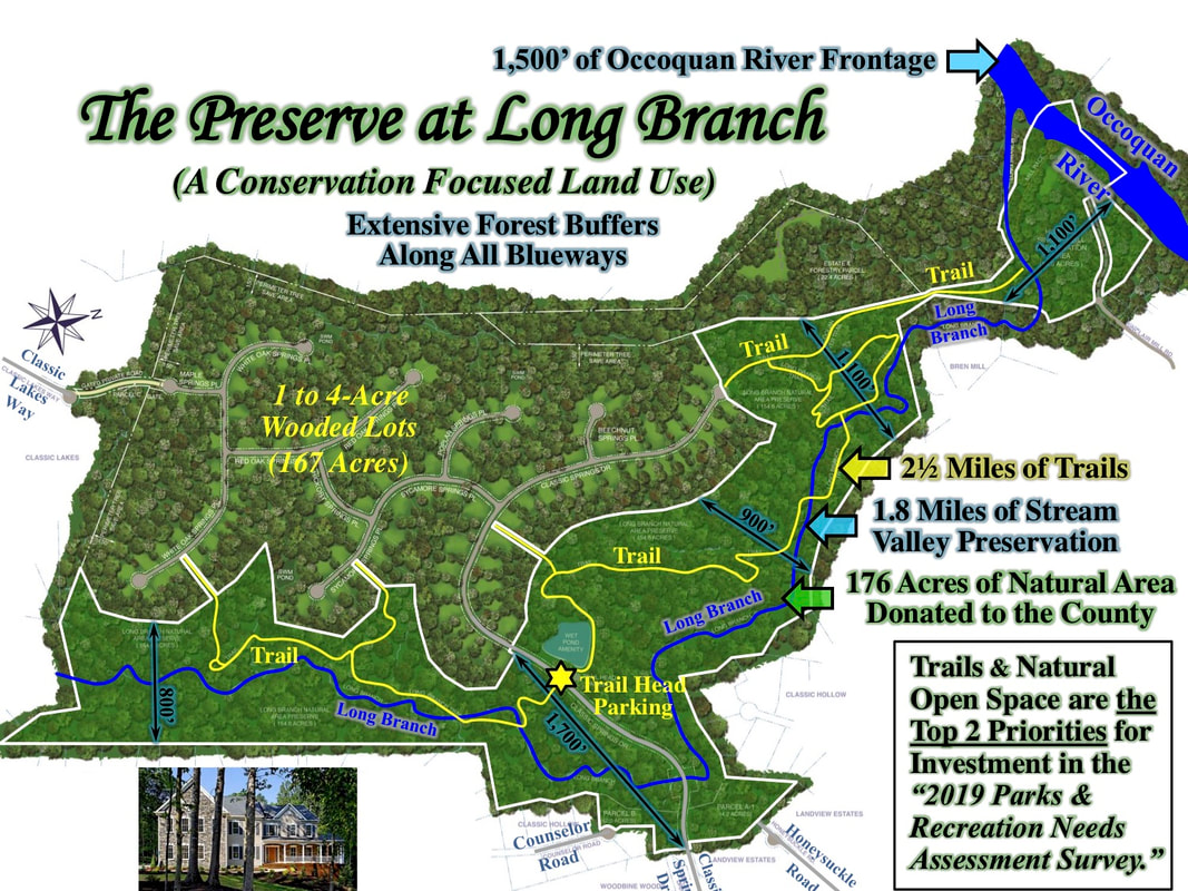
We did two up and backs on this hike. The map that is linked to at the bottom of the page is from the developer and shows trails past where Long Branch is crossed in the northeast corner of the map. Those trails don’t exist yet. The northeast section that we did was about a mile up and a mile back while the southwest section that we did was about a half mile up and a half mile back. So it felt like we did about 3 miles. We took a break where the trail was supposed to cross Long Branch.
I conversed with a number of people on this trip. The majority of them are involved with one trail organization or another. I was the lone independent here. We got done with the first up and back by 2:30 PM. We returned to the parking lot, took a break, then started the second up and back. This segment was southwest direction wise. It only went about a half mile, then ended in a small loop.
We again took a short break, then headed back to our vehicles. The hike ended around 3:30 PM. There is another trail in Fairfax County, VA that goes along a stream called Long Branch. It is nice that these trails are for the general public and not just for the home owners in this development. This was a great weekend hiking wise. I’ll rest up during the snow that is expected later this week..
Mike C


< Previous Trip Log | << Outdoors | Next Trip Log >