This page may contain an affiliate ad banner and/or text link. If one clicks/taps on this link and then makes a purchase, I sometimes receive a small commission. Please patronize our advertisers.
This roughly 3 mile series of up and back hikes occured on Wednesday, October 1, 2025. It was just me on this one.
I’m always searching for new places to hike. So when I came across the Sperryville Trail while doing a search, I decided to go and check it out. Then I drove out to Sperryville, VA to see what this trail was all about..
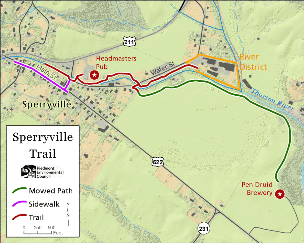
I arrived at around 9:30 AM and parked in the Rappahannock Pizza Kitchen parking lot on Main ST or US522. I walked about 100 feet north on US522. When it turned right I crossed the street, walked another 50 feet and turned left onto the Trail. This trail goes by different names. The sign said Sperryville River Walk. The map said Sperryville Trail. And a Google search brought up Rappannock Trail Network.
The weather was very pleasant. Cool and in the mid 60’s. I then was walking along the Thornton River going upstream. The trail was sandwiched in between this river and various businesses and residents’ homes. It was a short, nice walk.
According to:
The Thrornton River starts about half way up US211 west at Thornton Gap on the way to Skykine Drive. It runs east parallel to US211 until it reaches Sperryville. Then it heads in a southwesterly direction into Culpeper County where it empties into the Hazel River.
After about 600 feet the trail came out to someone’s backyard. They probably couldn’t get permission to route the trail further upstream from some residents. So I crossed Main ST and was walking northward. When I got to the edge of town a paved path continued. But I turned around.
Then, I backtracked to the US522 turnoff and turned left. I immediately crossed the street and found a trailhead across from where I started. So I started walking over a bridge. I followed the path to a building that was originally a school. It has been many busineses since then. It is a diner and bar now and the name escapes me. I then walked in front of the building and lost the trail. I asked a gentleman that was leaf blowing the grass where the Sperryville Trail was. He said that it was behind the building. I then got back on the trail.
There was an older couple and their dog hiking as well. We passed each other a few times. These were the only people that I saw on a Wednesday morning. I’m sure that it is more crowded on the weekend. The trail was only blazed with stickers at intersections. I made a few wrong turns. At around the 1 mile mark I had to make a decision. Explore the River District or the Pen Druid Brewery. I chose the brewery. So I turned right on Water ST, srossed over the Thornton River and turned left onto a mowed path.
This mowed path went across a field and ended up at the brewery. I thought that I had reached the brewery after about 750 feet. But after I got a wiff of the smell of it, I knew it was the city Water Treatment Plant. I kept walking a bit farther until I went through a section of fence that had been removed. There was no tree cover on this stretch. It was hot and buggy. So I decided to turn around.
When I got back to Water ST I decided to take that out to US522. As I was turning right to walk back to my vehicle I saw an “Under Contract” real estate sign in front of the land that I had just walked on. So I hope that the new owner does not close the mowed grass section.
According to:
a number of organizations such as the Sperryville Community Alliance, Rappannock Community Fund and The Piedmont Environmental Council helped to make this trail a reality. This trail was conceived in 2021 and was opened in 2023.
In closing, while I don’t think that this trail should be a sole destination, I do think that portions of it would be a nice walk while driving through the area to get to other destinations. A number of towns, cities and counties in Virginia are building and promoting trails within them That’s a good thing for both those municipalities and the hikers that they attract.
Mike C


< Previous Trip Log | << Outdoors | Next Trip Log >