This page may contain an affiliate ad banner and/or text link. If one clicks/taps on this link and then makes a purchase, I sometimes receive a small commission. Please patronize our advertisers.
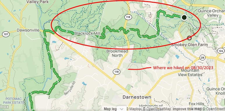
This 5.4 mile linear hiker took place on Wednesday, August 30, 2023. It was me and my cousin Ron Calabrese on this trip.
This was not an easy hike. I thought that we would be hiking beside Seneca Creek for this trip. However, there was more to it. Please read on…
I got to the MD28 trailhead parking area around 7:30 AM. Ron arrived around 8:00 AM. There are no signs for this trailhead parking lot on MD28. It is located about 250 feet east of the Seneca Creek bridge. It holds about 15-18 vehicles.
So we left Ron’s vehicle at the MD28 Trailhead parking lot and drove my vehicle over to where Seneca Creek intersects Riffle Ford RD. There is room for about a dozen vehicles to park along the northbound shoulder of this road. I would think that all parking areas for this trail would fill up quickly on the weekend.
We got on the trail around 8:30 AM. This was a 2.5 mile stretch to Germantown RD. All in all this was a pleasant stretch. There was some forest walking, some power line walking and some open field walking. The terrain was rolling on this stretch. There was one slight up around the .75 mile mark as we ascended a hill parallel to a gas line. We again walked along a powerline, went into the woods again and had some very nice scenery until we reached Germantown RD around 10:00 AM.
There are two parallel trails along Seneca Creek. We were on the Seneca Creek Greenway, which is signed for hikers, runners and horse riders only. The Seneca Ridge Trail is for bikes only. It is more “squigly”. A number of bicyclists like these meandering type of trails.
This next stretch of trail between Germantown and Black Rock RDS was a tuffie. It was all in the woods. However, after about a half mile in we crossed a bridge over a tributary, then started a steep up along the side of a dry creek bed for about a quarter mile. I believe the trail builders did this because the terrain next to the creek was a cliff or very rocky. When we got to the top of this long pull we had level trail for a very short stretch, and then a very long down.
The rest of the trail was fairly level and close to Seneca Creek. We saw the first two people today on the trail sitting next to the creek. It appeared to be a mother and her son. We got to Black Rock RD shortly after 11:00 AM. We took a break on a guardrail there because that long up kicked our butts. We then walked past an old mill. The Seneca Ridge Trail was now on the west side of Seneca Creek and the Seneca Creek Trail was on the east side of the creek. They switched sides.
Shortly after we passed the old mill we got momentarilly lost, but then found the trail again thanks to our AllTrails apps. Next we had another steep up. This one was shorter than the last one: only about 250 feet. But again, it tuckered us out. The trail then leveled out and even went slightly downhill the rest of a trip. We passed a father and his two kids, one in a backpack carrier, on this stretch. About a qiarter mile before we reached the trailhead parking lot we were walking parallel to VA28 but were just inside the woods. We got back to Ron’s vehicle around 11:45 AM. Ron then shuttled me back to my vehicle on Riffle Ford RD. I got home around 2ish.
Again, this was not an easy hike. However, there was some nice scenery, Ron and I had some great conversations and I lost a few more pounds. There is a 7 mile stretch of this trail between MD28 and the C&O Canal Towpath and the Potomac River. I would like to do this stretch some time either this fall or next spring. Anyone want to join me?
Mike C


< Previous Trip Log | << Outdoors | Next Trip Log >