This page may contain an affiliate ad banner and/or text link. If one clicks/taps on this link and then makes a purchase, I sometimes receive a small commission. Please patronize our advertisers.
This roughly 5 mile moderate loop hike took place on Friday, March 6, 2026. It was only me on this one.
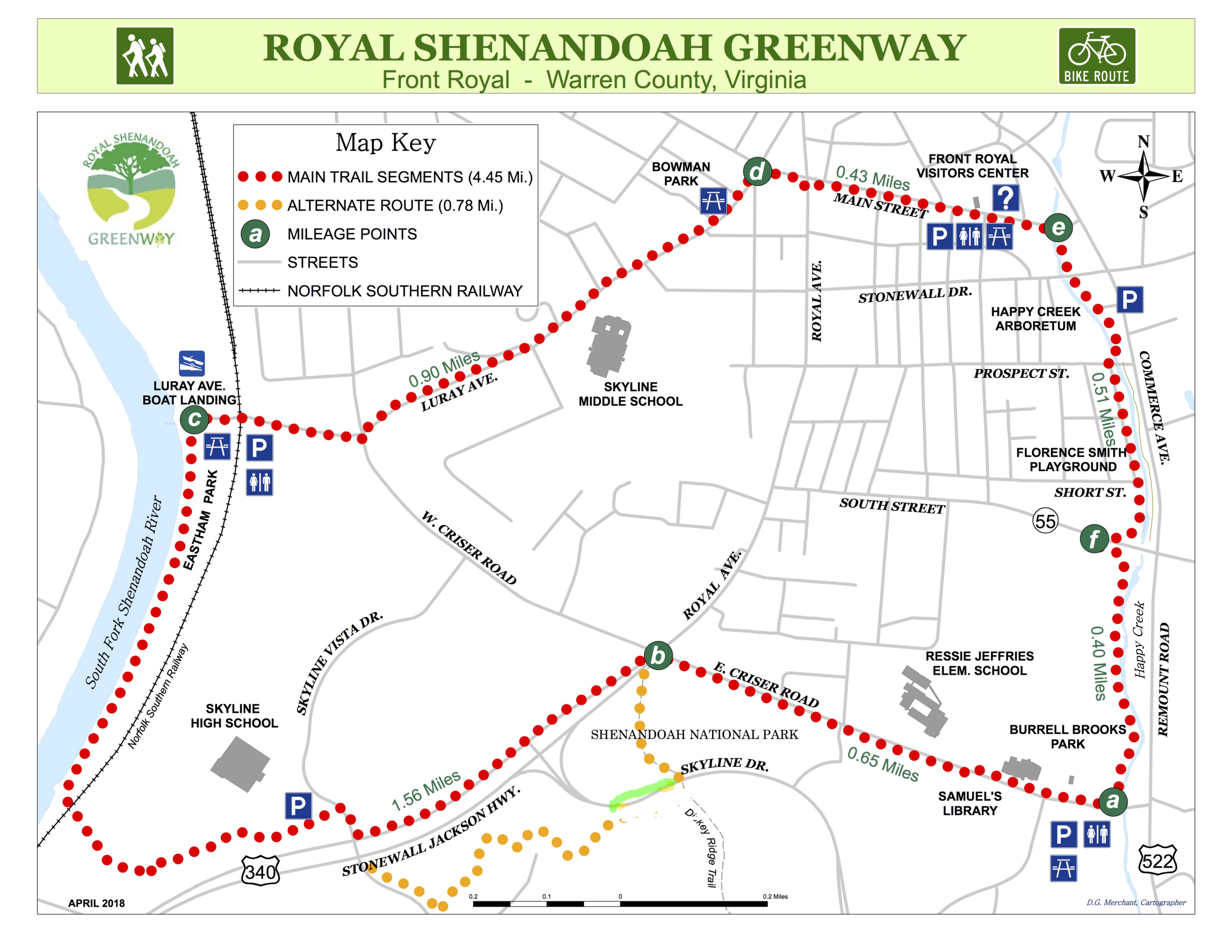
I wasn’t sure that I was going to do this hike until the last minute because of the ever changing weather forecast. Around 9:00 AM I saw that the rain was ending so I decided to go and do this hike. I got to Burrell Brooks Park near the intersection of Criser and US522 Remount RDS in Front Royal, VA around 10:30AM. There is adequate parking at this park as well as a portapotty, which was not full but very dirty on the inside.
This was a counteclockwise hike. I started by walking in a northwesternly direction on E. Criser RD. The majority of this hike was on concrete sidewalks, asphalt paths or asphalt bike lanes. Only the upcoming stretch within Shenandoah National Park would be on dirt trail. Criser RD was a good sized up, then a good sized down. What was amazing was that the boundry for SNP was right next to this road.
After about .65 miles I got to the intersection with US340 Royal AVE/Stonewall Jackson HWY. I turned left and immediately turned left onto the Dickey Ridge Trail. I last hiked this trail around 25-30 years ago. I took this trail for about a third of a mile and got to Skyline DR. Here is where I had a map issue. The map inferred that that you had to continue on the Dickey Ridge Trail for a short distance, then turn right. However, I must have walked another third of a mile and did not see the turnoff. So I consulted Google Maps and Alltrails. It turns out that I was supposed to turn right onto Skyline DR north for about 500 feet, then turn left onto a trail. I will mark up the map to show this issue so others won’t waste half an hour getting lost like I did.
OK, so I turned left onto this blue blazed trail. BTW, all hiking side trails in SNP are blue blazed. Only the AT is blazed white. There are also some yellow blazed horse trails. This was evidently an old road that I was on. After a few thousand feet the trail turned right and went up some log stairs. Up ahead I saw an old wooden barricade across this old road. The trail went up, then a long down. After about .2 miles I came out to a road. The familiar SNP concrete post actually had the word Greenway on it with an arrow pointing left when looked at from the front. But it was a right turn from behind. So I walked another 500 feet and made it to the intersection of Browntown RD, US340 and Skyline Vista Drive.
Then I crossed the road, turned left onto a paved trail and was going around Skyline High School and was entering Eastham Park. I was starting to see more people now. A number of them looked like high school students taking a walk. That sure beats sitting in study hall. I also saw a number of retirees like myself walking. I would pass one threesome three times as they were doing up and backs on this stretch. I crossed under a railroad track via a bridge and was then walking north and next to the Shenandoah River. They did a nice job on this park. There were benches, dog runs and playing fields along it. This stretch lasted about a half mile.
Next I turned right at the Luray AVE boat landing onto Luray AVE. I used the portapotty there and then, after passing under another railroad bridge, started a .9 mile eastward climb towards Main ST. This was a long, tough up. I had to road walk in some areas, walk in a bike lane in others and sidewalks for a short stint. I took plenty of breaks. At one point I took a break and held onto a sign post in front of a house. I must have looked awful as a lady actually came out of her house and asked me if I was OK. I told her that I was just taking a break but thanks for checking up on me. The long up continued to just past the middle school. Then it started to level out. It was around 12 noon at this point.
When I got to the corner of Luray AVE and Main ST I turned right and crossed over to the the other side of the road. I was then walking through the downtown area. There were a number of vacant stores like most small towns. But they had some nice restaurants, shops and a movie theatre. I stopped in the local outfitter there and walked around their store. Very nice selection. The guys running the store had grey beards and looked like former thru hikers. I then walked to the visitors center where I used the facilities and refilled my water bottle.
Finally, I was on the home stretch. Just .9 miles to go along Commerce AVE/Remount RD. I was now headed southbound. I went past a playground and an arboretum. There were also a few homeless men along this stretch. The first two that I passed were sleeping on park benches. I would pass two more right before the hike ended. The signing was good along this stretch. When I got to VA55 South ST the trail turned right, went about 500 feet and had a crosswalk with a manually operated traffic light. This was nice as I probably would have had to wait a while to cross. I then skirted Royal Plaza, walked along a nice stretch of Happy Creek, then cut the corner of Criser and Remount when I saw a shortcut trail and my vehicle in the distance. Then I was done at 1:45 PM.
Three hours and fifteen minutes was not good time. However, I wasted a half hour at Skyline DR and I had to take a lot of breaks doing that long up between the boat landing and Main ST. Even with these issues I still enjoyed doing this trail. I lived in Front Royal for 8 years between 1976 and 1984 and have fond memories of my time here. The area has improved greatly since that time. No more pungent odor from the viscose plant that used to be here. They have a trolley like bus service now and there is a lot of new housing being built. And there is also a Happy Creek Greenway. I’ll have to check that one out.
Mike C


< Previous Trip Log | << Outdoors | Next Trip Log >