
This page may contain an affiliate ad banner and/or text link. If one clicks/taps on this link and then makes a purchase, I sometimes receive a small commission. Please patronize our advertisers.
This 1.5 mile up, 1.5 mile back or 3 mile hike took place on Monday, December 29, 2025. It was just me on this one.
I left Manassas, VA around 8:45AM and was supposed to get to the trailhead of the Dahlgren Railroad Heritage Trail by around 10:00 AM. I input the following address into Google Maps:
10431 Bloomsbury Road, King George, VA
which is the western terminus of this trail. However, I ended up at the end of a Cul de Sac on Robin Hood RD. I did pass the trail on Indiantown RD VA 610 so I knew that I was close. So I had to go back out to VA 218 and try different combinations of roads into Google Maps. The combination of Caledon RD and Bloomsbury RD got me to the correct street. Then it was just a matter of finding 10431, which I did eventually.
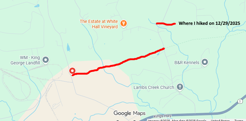
So I ended up starting this hike around 10:15 AM. The temperature outside was 57 degrees. Fantastic! The goal today was to hike eastbound on this trail for about an hour, then turn around and come back. This trail is 16 miles long. It starts on Bloomsbury RD in King George, VA at the western end and terminates at US301 near the Potomac River. You are supposed to get a permit to hike this trail before you do so. I tried. Twice. I clicked on the pop up on their website which, by the way, is:
Dahlgren Railroad Heritage Trail
last week and nothing happened. Then the day before this hike, I tried again. I filled out the form and submitted it. The form said that I would receive the permit via email. I never got it. Oh well. The history of this trail is long and detailed. I won’t go into it here so consult their website for the particulars.
There was an old caboose and boxcar at the trailhead. They looked like they needed refurbishing. The first quarter mile of the trail still had rails on it. There were none afterwards. I saw a cell tower to the distant south of this trail. I had 4 bars for Verizon and 5G. I was either passed by or I passed 7 hikers and one runner who had a dog. I imagine that this trail is packed on weekends. There were milage markers. The old wooden crossties for the rails were in piles along the trail. Though it was winter, I would think that tree canopy would be very nice and shady in the summer.
I made it to the first road crossing, VA694 Lambs Creek Church RD by around 11:00 AM. I took a break, drank some water and then started my return trip. It was very peaceful walking along this trail. It was very level. There were farm fields on each side of this stretch along with occasional dirt crossings for the farmers to traverse between their fields. The houses in this area were an eclectic mix of very nice, expensive homes and those that belonged on the set of the American Pickers TV show.
My return trip ended back at my vehicle at around 12 noon. The themomometer said 67 degrees. Wow! I got home around 1:15 PM. The temperature was 52 degrees and falling fast. The winds were whipping up as well. This was a neat trail. It appears to be a runners trail as there are a number of races along it. My son John has run this trail many times.
Not sure if I want to section hike this trail or not. It’s a long drive. But it would be a neat challenge. I’ll have to think about it. But it was an enjoyable day. I discovered a new trail, met some nice people and witnessed the beauty of nature.
Mike C


< Previous Trip Log | << Outdoors | Next Trip Log >