
This page may contain an affiliate ad banner and/or text link. If one clicks/taps on this link and then makes a purchase, I sometimes receive a small commission. Please patronize our advertisers.
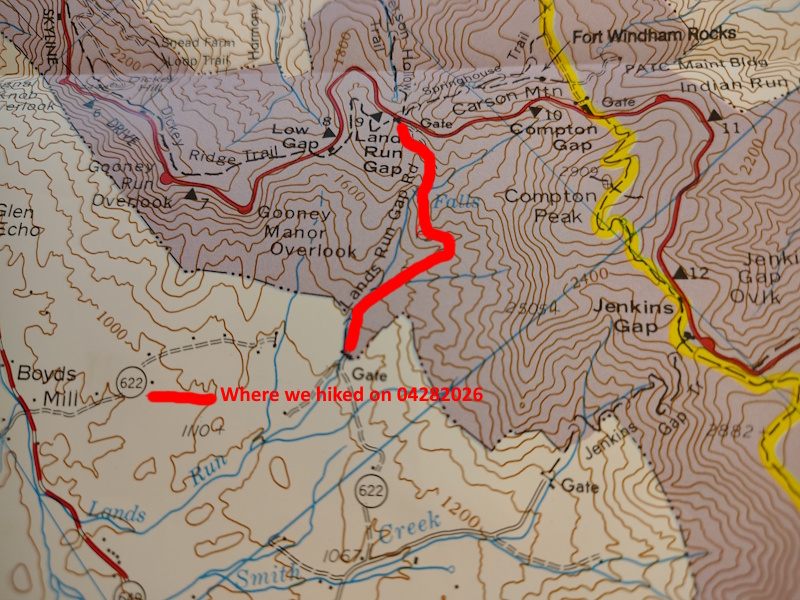
This 2.5 mile down, 2.5 mile up (5 miles total) day hike took place on Tuesday, April 28, 2026. It was sponsored by:
and was led by Sue Collins. Elevation changes were about 500 feet each way.
I left Manassas, VA around 7:30 AM and got to the Land’s Run Gap Fire Road at at mile 9.2 around 9:40 AM. I saw things at the park while driving to the trail head that I have never seen before. Things like no one working at the entrance station and numerous workers working on fixing things, painting things and fixing stone barriers all along Skyline Drive. Why? The Royals are coming! More on that later.
There were 14 hikers on this trip. Hike leader Sue started us right at 10:00 AM. We would walk downhill on Lands Run Gap Fire Road for about a mile and a 100 foot down and crossed Lands Run. Just below this crossing there was a small water fall. It was tough to get to a good place to see this waterfall but we did. It was neat. At this point, Sue offered to those that wanted a shortened hike that they could now hike back to their vehicles. Four people took advantage of this invitation, The rest of us continued downhill towards the park boundry.
This was a tough decision for me. I could have just done 2 miles and a 100 foot elevation change. But I wanted to lose some weight and get in shape for a hike that I will be leading on Tuesday, May 26th. So I went ahead and did the remaining 4 miles and 400 foot down to the western park boundry. The fire road was very rocky and steep. I slipped on some loose rocks and fell down. But my fellow hikers picked me up. We had some nice conversations on the way down.
We made it to the park boundry around 11:30 AM. This fire road connected to VA622 outside of the park. Most of the fire roads in SNP were existing roads that went up over the mountains and back down the other side. These fire roads are now gated at the park boundry. We took about a 15 minute break and then started the 2.5 mile and 500 foot elevation change back to our vehicles.
Ups are not my strongpoint. I have never been good on ups. So I immediately fell to last place on the way up. Our leader Sue as well as the other hikers tooks breaks and allowed me to catch up with them. It was not easy. I felt OK on the way up. I just couldn’t keep up with the others. I was the oldest hiker on this stretch so I did have a bit of an excuse. The weather during this hike was in the 60’s with varying degrees of sun and cloudiness.
We finally made it back to our vehicles around 1:00 PM. 3 hours to do 5 miles with a 500 foot elevation change each way isn’t bad. I thanked everyone for stopping to wait for me on the way up and then I headed home. On the way out of the park I noticed that the size of the workers sprucing up the entrance station of SNP had grown to over 50 workers. And there were more workers sprucing up the overlooks and the buildings. I’m sure that the park will look great for the pending visit of King Charles and Queen Camilla.
In closing, I got home around 2:40 PM, took a shower and am now writing this trip log. If you want some tough hikes that are guaranteed to help you lose weight, hike the fire roads of Shenandoah National Park, VA.
Mike C


By Sue Collins


< Previous trip Log | << Outdoors | Next Trip Log >