This page may contain an affiliate ad banner and/or text link. If one clicks/taps on this link and then makes a purchase, I sometimes receive a small commission. Please patronize our advertisers.
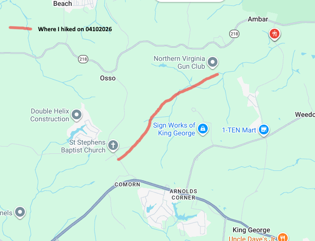
This 4.2 mile hike (2.1 miles up, 2.1 miles back) day hike took place on Thursday, April 9, 2026. It was just me on this one.
This was the perfect day for a hike. I arrived at the Comorn RD trailhead parking at about 10:00 AM and immediately started hiking. The temperature was 47 degrees. The goal was to hike 2.1 miles to Peppermill Creek East and back again. As usual, the trail was fairly level though I did detect a slight up and later a slight down along the way. The trees were all startung to fill in leaf wise. I was able to be at peace alone in the woods. I only passed one other senior hiker going the opposite way.
During this stretch I noticed that certain landmarks were different than they were portrayed on Google Maps. For example, Google Maps showed 2 crossings for Tomahawk DR. However, there was only one but there was a short side trail going to Tomahawk DR as it paralleled the trail for about .2 miles. So I changed that point on the distance calculator. Also, some of the streams were at different points than were shown on the map. I couldn’t keep track of them but the number of streams were correct so I made no changes to the distance calculator. Also, the AllTrails app has gotten a lot better as the recording function now works when you minimize the app to take images, look at Google Maps, etc. and it now shows backtracking on the app.
I got to the 6 mile marker right where Peppermill Creek East crossed under the trail. There was a tree root protruding from a hill so I used that to sit down and take a break. It was now 11:00 AM. I drank an Ensure, took a multipurpose vitamin and ate a Chomps, which are supposedly healthier Slim Jims. There was a nice house and farm on the field on the south side of the trail. Then I started my return trip around 11:15 AM.
On the way back I saw a golf cart like four wheel vehicle headed towards me on the trail. At first I thought that they were hunters and I was a bit concerned. But they stopped and greeted me and said that they were inspecting the trail since there is an event this weekend and asked if I saw any issues. I said no, everything looked great. So they said thanks and continued riding eastbound on the trail.
As usual, the return trip appeared to go faster than the original trip. I don’t know why that is always the case. The temperature was in the low 60’s when I finished this hike at around 12:15 PM. It was a bit chilly at the beginning but I was sweating at the end. I made it home around 1:30 PM and had the rest of the day to shower, rest and get started on this trip log. I’m glad that I got out to hike today as I thought it was the best day weatherwise this week.
So, here is where I stand as far as completing this trail. I have hiked 6 miles so far. The total is really 12 miles since I have done all up and backs. Here is how I plan to complete the remaining 10.5 miles of this trail:
- Hike westbound from Indiantown RD to Peppermill Creek East and back again; 1.9 miles up, 1.9 miles back, total of 2.8 miles.
- Hike eastbound from Indiantown RD to Caledon RD and back again; 2.8 miles up, 2.8 miles back, total of 5.6 miles.
- Ride my bike westbound from Owens RD West to Caledon RD and back again; 4.0 miles up, 4.0 miles back, total of 8 miles.
- Hike eastbound from Owens RD West to the US301 eastern terminus and back; 1.8 miles up, 1.8 miles back, total of 3.6 miles.
If I do one of the remaining segments each month, I should be able to complete this trail by August, 2026. And I will have hiked and/or biked 35.2 miles to complete a 17.6 mile trail. Unless I can find someoune else to hike these sections with me and eliminate that up and back. Any takers?
Mike C


< Previous Trip Log | << Outdoors | Next Trip Log >