
This page may contain an affiliate ad banner and/or text link. If one clicks/taps on this link and then makes a purchase, I sometimes receive a small commission. Please patronize our advertisers.
This 5.2 mile hike (2.6 miles up and 2.6 miles back) took place on Wednesday, February 18, 2026. It was just me on this one.
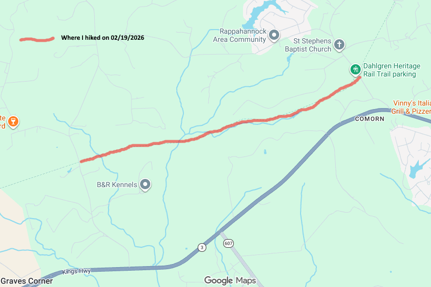
I left Manassas, VA at around 8:30 AM and made it to the Sheetz at the corner of VA3 Kings HWY and Dahlgren RD at around 9:30 AM. I took some shortcuts around Fredericksburg thanks to Waze and Google Maps. I used the facilities, bought a bakery item and then drove to the trailhead where the DRHT crossed Lambs Creek Church RD. I then started the hike around 10:15 AM. The goal today was to hike from Lambs Creek Church Road to Comorn RD and back.
The temperature when I started this hike was 45 degrees and it was partly cloudy. Great weather to hike in. The trail appeared to have a 1% grade going west to east. Noticable but not a problem. There were railroad cross ties still buried on the trail along this stretch. However, the rails were gone. Again there were numerous road crossings along this stretch for adjacent property owners to get to their parcels.
It was a great time to just admire the beauty of nature and let my mind wander. I made sure to drink water and take various items like vitamins, Voke Tabs, a sandwich and Ensure along the way to keep my energy up. During this hike I only passed two women walking their dogs. They were spaced about 500 feet apart. I again passed one of them on the return trip but not the other. Only about 5% of the trail that I hiked was covered in snow. The rest was clear.
There were a few blow downs around mile 1.7. I will report these to the trail maintaining organization. What is amazing is that when this railroad was originally built, they leveled the mountains and filled in the valleys to make this RXR bed level. So I would occasionally be looking down between 50 and 100 feet to the land below the railroad bed. And there were times that I would be hiking between mountains on either side of the trail that were 50 to 100 feet tall. The trail was not totally straight along this stretch but made some slight curves as it was heading eastward towards US301 in Dahlgren, VA.
I got to Comorn RD around 11:40 AM. There was parking for two or three vehicles at this trailhead. I took a quick break and started my return journey. It was then 50 degrees out.
Whenever I do an out and back hike, the return trip usually takes less time than the original trip. I believe the reasons are that I knew what to expect going back and I had a slight downhill on the way back. I also took less breaks on the way back as I wanted to get home before rush hour started. One thing that slowed me down were those round prickly things that fell from the trees and were on certain areas the trail. Landing on one felt weird. I have one pictured on the right.
So I made it back to my vehicle around 1:15PM. Let’s see, 5.2 miles divided by three hours equals 1.7 miles and hour. Now, I am a slow hiker but that rate is OK to me. It was 61 degrees when I finished this hike. Nice. Verizon cell service had four or five bars the entire trip. I got home around 2:30 PM. So I beat the rush hour. This was an enjoyable hike.
Now, the upcoming stretch between Comorn RD and Indiantown RD is 4 miles. However, If I do another up and back, it will be 8 miles. Not sure if I want to do that. So if I can’t find anyone to bring a second vehicle and hike it with me, then I will probably only do from Comorn RD to the eastern crossing of Pepper Mill Creek and back. That will be 1.9 miles each way. Then, next time, I can do from Indiantown RD to the eastern crossing of Pepper Mill Creek.
If I have to do up and backs for the rest of this trail, I will have hiked 33.4 miles to do a 16.7 mile trail. Does anyone want to join me for some of the upcoming segments? Please let me know.
Mike C


< Previous Trip Log | << Outdoors | Next Trip Log >