
This page may contain an affiliate ad banner and/or text link. If one clicks/taps on this link and then makes a purchase, I sometimes receive a small commission. Please patronize our advertisers.
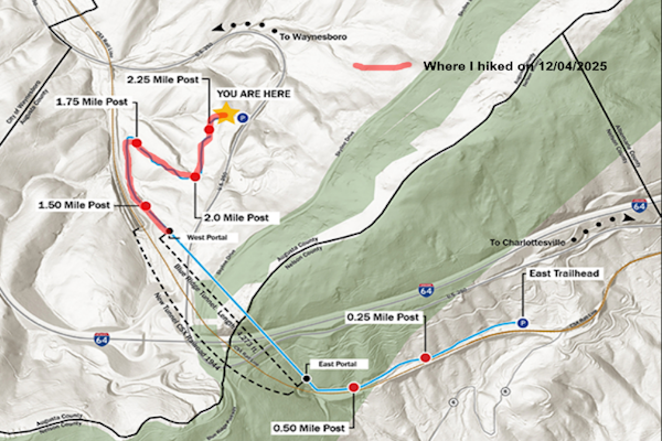
This was a 1 mile in, 1 mile back out recon of the western approach trail for the Blue Ridge Tunnel in Waynesboro, VA. It was just me on this one.
I hiked the eastern approach trail and the Blue Ridge Tunnel itself back in 2022. You can read that trip log
Here.
So today I wanted to explore the western approach trail to this tunnel. I left Manassas, VA around 8:45 AM and got to the western trailhead parking around around 11:00 AM. This was not a real parking lot but a semi-loop road that started and ended on US250. It had parallel parking spaces for two buses and about a dozen vehicles. There were portapotties present as well as trash cans and trailhead information.
When I started hiking the temperature was in the mid 40’s. It was a bit cloudy and there was a slight breeze. I wore a flannel shirt and my Omni-Heat jacket along with some glove liners and a stocking hat. So I was OK as far as keeping warm. The trail itself was crushed gravel, dual track and had a number of pretty good ups and downs. While probably not more than a hundred feet or so, it was enough that I had to take breaks while doing the up portions.
The trail builders utilized parking lot bumpers on the ups and downs to act as water diversion as well as erosion diversion devices. There were numerous informational signs along the way. There were mile markers that had started at the eastern trailhead and ended where I started. There were benches along the way and a few picnic tables as well.
After about .75 miles I could see where the current rail line diverged from this line and went through a parallel and wider tunnel right next to the hiking tunnel. I got to the western tunnel entrance at around 11:30 AM. I took a quick break, then turned around and started back to my vehicle. I got back to my vehicle by 12 noon, stopped at Arbys north of Charlottesville, VA for lunch, then made it back home around 3:00 PM.
Since I may be leading a hike on the eastern approach trail, the tunnel and this western approach trail that I was hiking on, I was trying to think of the best way to lead this one. I think that I will give the hiker three choices: 1) Just hike from the eastern trailhead through the tunnel, then turn around and hike back to the eastern trailhead. 3 miles total, up and back.; 2) Hike from the eastern trailhead through the tunnel and the western approach trail. There would be one or more shuttle vehicles waiting to take them back to the eastern trailhead and their vehicles. 2.5 miles total, linear; and 3) Hike the eastern approach , the tunnel itself and the western approach, then turn around and hike the western approach, the tunnel and the eastern approach back to their vehicles. 5 miles, total.
I’ll think on this one. This was a nice hike.This trail was designed, built and maintained very well. It was a great day to hike and I had the trail all to myself today.
Mike C


< Previous Blog Post | << Blog V2